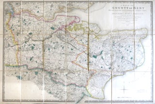
A Map of the County of Kent Drawn from the Topographical Survey Taken, by Order of the Honourable Board of Ordnance, ... Reduced from the Large Map in Four Sheets by a Scale of One Inch to Two Statute Miles.
London: Jas. Wyld, 1841. Map dimensions 59.5 x 89 cm, overall 63.5 x 94.5 cm. Finely engraved folding map of the county, dissected into twenty-four sections and mounted on linen, green silk trim to the edges, marbled paper to the folded end sections, folds into original green embossed cloth slipcase..... More
![Item #28506 [Bermondsey]. London Sheet XI.18. ORDNANCE SURVEY](https://bowwindows.cdn.bibliopolis.com/pictures/28506.jpg?width=320&height=427&fit=bounds&auto=webp&v=1484062537)
![Item #28510 [Walworth]. London Sheet XI.15. ORDNANCE SURVEY](https://bowwindows.cdn.bibliopolis.com/pictures/28510.jpg?width=320&height=427&fit=bounds&auto=webp&v=1484062537)
![Item #28511 [Waterloo Bridge & the South Bank]. London Sheet VII.74. ORDNANCE SURVEY](https://bowwindows.cdn.bibliopolis.com/pictures/28511.jpg?width=320&height=427&fit=bounds&auto=webp&v=1484062537)
![Item #33226 [Mayfair and South Marylebone]. ORDNANCE SURVEY](https://bowwindows.cdn.bibliopolis.com/pictures/33226.jpg?width=320&height=427&fit=bounds&auto=webp&v=1547819366)
![Item #33227 [St. Paul's Cathedral and the City]. ORDNANCE SURVEY](https://bowwindows.cdn.bibliopolis.com/pictures/33227.jpg?width=320&height=427&fit=bounds&auto=webp&v=1547819366)
![Item #18771 [Steyning and Northern Environs]. ORDNANCE SURVEY?](https://bowwindows.cdn.bibliopolis.com/pictures/18771.jpg?width=320&height=427&fit=bounds&auto=webp&v=1446578445)