![Item #26648 Plan of an Intended Railway from the Town of Lancaster to the Town of Preston in the County Palatine of Lancaster. [with] Enlarged Plans [of Twenty Four Sites on the Route plus a Plan of] Part of Preston. LOCKE, Joseph.](https://bowwindows.cdn.bibliopolis.com/pictures/26648.jpg?width=768&height=1000&fit=bounds&auto=webp&v=1457973042)
![Plan of an Intended Railway from the Town of Lancaster to the Town of Preston in the County Palatine of Lancaster. [with] Enlarged Plans [of Twenty Four Sites on the Route plus a Plan of] Part of Preston.](https://bowwindows.cdn.bibliopolis.com/pictures/26648_2.jpg?auto=webp&v=1457973042)
![Plan of an Intended Railway from the Town of Lancaster to the Town of Preston in the County Palatine of Lancaster. [with] Enlarged Plans [of Twenty Four Sites on the Route plus a Plan of] Part of Preston.](https://bowwindows.cdn.bibliopolis.com/pictures/26648_3.jpg?auto=webp&v=1457973042)
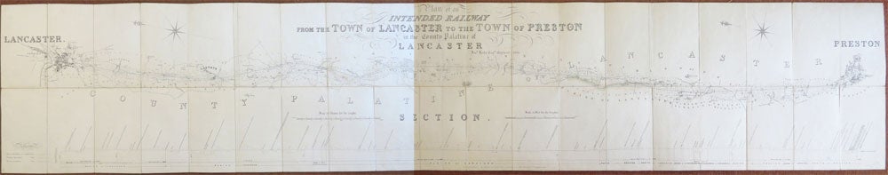
Plan of an Intended Railway from the Town of Lancaster to the Town of Preston in the County Palatine of Lancaster. [with] Enlarged Plans [of Twenty Four Sites on the Route plus a Plan of] Part of Preston.
Birmingham: Lithographed by Binns & Clifford (Surveyors &c.), 1836. Overall dimensions (1) 41.5 x 230 cm and (2) 41.5 x 96.5 cm. A very long folding map on a scale of approximately 4½ inches to one mile with a cross section of the landscape on route running underneath on a scale of one inch to a hundred feet for altitude, the enlarged plans on the second sheet are of various sizes and are either on a scale of one inch to 10 or 25 chains, (1) dissected into 38 sections and (2) into 18 sections, both mounted on linen, folds into the original black morocco slipcase, the brief title gilt lettered on the upper panel along with Locke's name. The foldover flap of the slipcase wanting, though the other edges of the case have been neatly restored, the maps in excellent condition. Scarce, with no other copies traced. Binns' name is repeated at the lower right corner along with that of T. Hodgson, billed as Surveyors of Lancaster. Item #26648
Price: £1,450.00