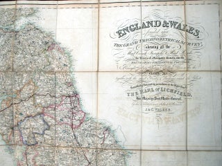
England and Wales founded upon The Grand Trigonometrical Survey; shewing all the Mail Coach, Turnpike & Rail Roads, the Rivers & Navigable Canals, also the Boundaries & Divisions of Counties, the extent of the Boroughs, County Election & Polling Places, under the Reform Act together with the sand Banks & soundings round the Coast ...
[London]:, 1840. Map dimensions 131.5 x 101.5 cm, overall dimensions 134 x 104 cm. Large folding map of England and Wales. Attractive original outline colour marking out boundaries and routes. The whole dissected into 48 sections and mounted on linen. Folds between original green cloth covers decorated in gilt to..... More