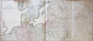
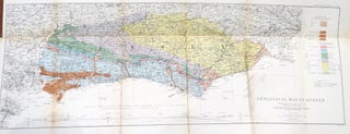
Theatre of War. A Map of the Country Surrounding the Baltic Sea, Comprehending the Northern Part of Germany, Poland & Russia,
London: C. Smith, June 4th, 1812. Dimensions 39 x 110.5 cm. Large copper engraved map of the theatre of the war in northern Europe, covering the extents from the North Sea across the Baltic region to Nizhny Novgorod in the east. Printed over four irregularly sized conjoined sheets folded twice..... More
![Item #37548 [Coll]. STANFORDS](https://bowwindows.cdn.bibliopolis.com/pictures/37548.jpg?width=320&height=427&fit=bounds&auto=webp&v=1613663320)
![Item #35626 [Ordance Survey Map of East Hampshire, West Sussex and South-West Surrey]. SUSSEX](https://bowwindows.cdn.bibliopolis.com/pictures/35626.jpg?width=320&height=427&fit=bounds&auto=webp&v=1580822761)
![Item #46482 The Making of the Nuremberg Chronicle. [By...] Assisted by Joyce Lancaster Wilson....](https://bowwindows.cdn.bibliopolis.com/pictures/46482.jpg?width=320&height=427&fit=bounds&auto=webp&v=1709130972)