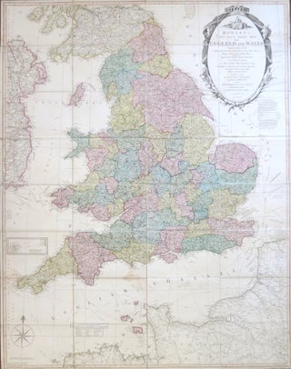
Bowles's New Four-Sheet Map of England and Wales: Comprehending all the Cities, Boroughs, Market and Sea Port Towns, Villages, Lakes, Rivers, Forests, Ruins, Canals, and Principal Seats of the Nobility, described by...
London: Printed for proprietors Bowles & Carver, 1810. Map dimensions 130 x 101.5 cm, overall 132.5 x 103.5 cm. Large folding map with original colour in block and outline demarcating the counties, ornate title cartouche to the upper right corner with an explanatory key adjacent, inset map of the Isles..... More